Water

Protecting a valuable resource

At Coastal GasLink, the safety of our people, environment and communities is our number one priority. We continually work to identify leading technologies to safely construct our project, such that we are protecting the environment and highly valued natural resources – including waterways. 

Our 670 km project route crosses many bodies of water, and we approach each one with the utmost care. For all bodies of water we may cross, we’ve conducted extensive studies and field work to determine the most environmentally responsible method to build our project. Our approach is validated by the approvals and permits we have in place from the BC Environmental Assessment Office and the BC Oil and Gas Commission.

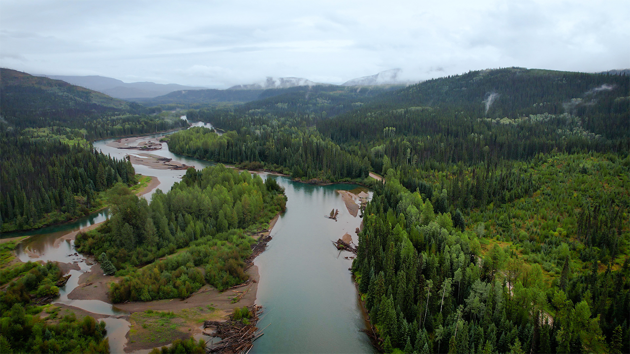
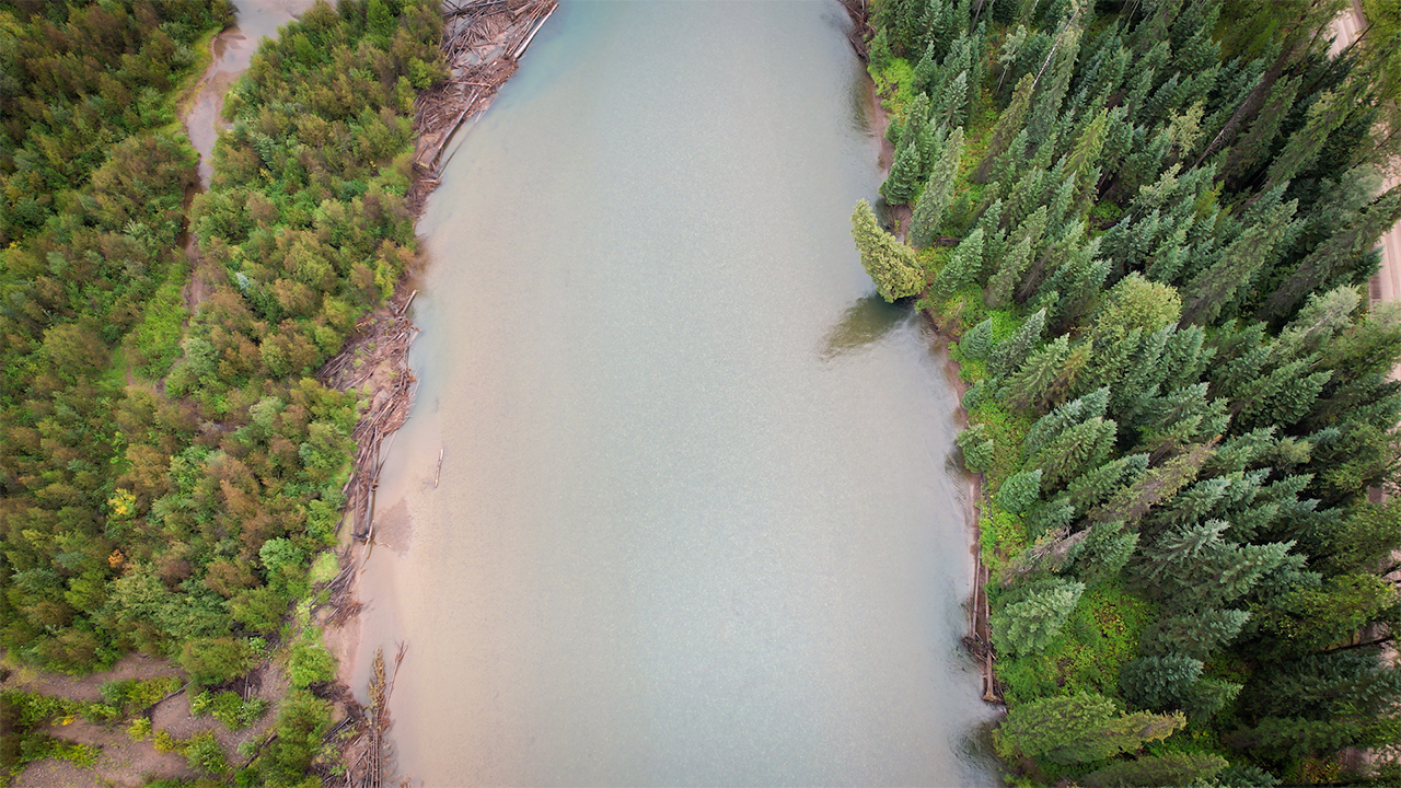
Safely crossing the Morice River

We recognize that the health of the Morice River is vitally important to the surrounding communities and the ecosystem of the region. Together with subject matter experts and input from Indigenous communities, a significant amount of environmental and technical assessments have taken place to inform the selection of the safest and most effective crossing methodology.

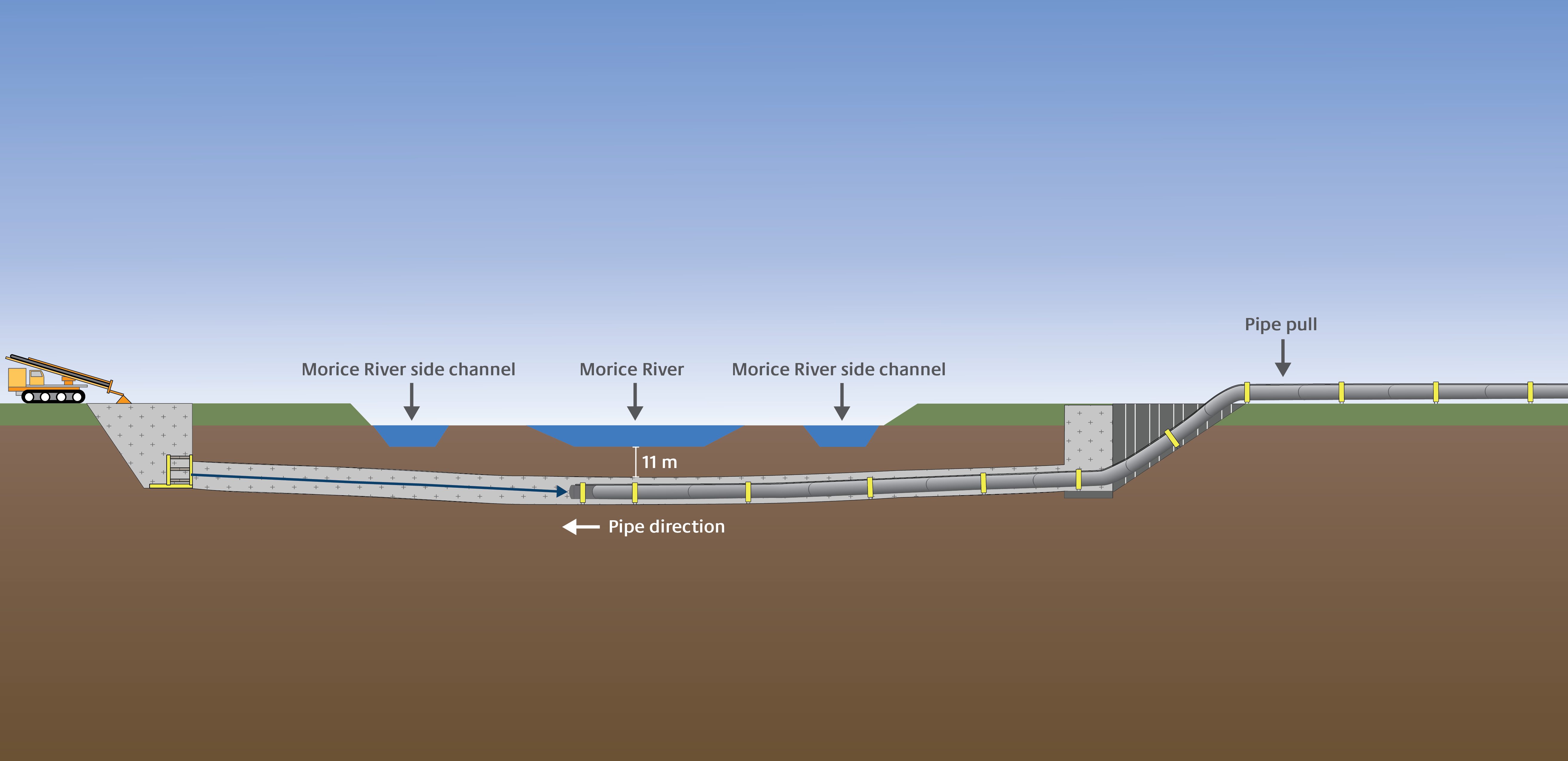
We are confident that micro-tunneling, one of the most expensive and technologically advanced forms of trenchless crossings, is the safest method to cross the Morice River.

At its closest, the tunnel will be approximately 11m below the bed of the river and does not pose a threat to any fish eggs that may be above the tunneling activity. Coastal GasLink is not carrying out blasting at the Morice River and is not expected to affect spawning fish or incubating eggs that may be above the tunneling activity.


cgl morice river aerial 1280x720.jpg

Learn how we safely implement trenchless water crossings.

cgl morice river 1280x720-2.jpg

Micro-tunneling uses hydraulic jacks and a tunnel boring machine to push concrete casing segments through the soil deep under water bodies in a way that minimizes risk and disposal volume. The pipeline is then safely pulled through the tunnel created by the concrete casing. Micro-tunneling is a remote-controlled excavation method that results in limited environmental, economic, or social disturbances.  

This won’t be the first time that micro-tunneling is used. In fact, it’s used regularly for public works and infrastructure projects, such as hydro lines, sewer systems and other utilities in BC, and we are proud of the work we have done with Indigenous and local communities to select this method at the Morice. Recently, TC Energy utilized micro-tunneling in our Sur-de-Texas project in Mexico. This project holds the world record for the longest micro-tunnel for an offshore-onshore pipeline, and like our other water crossings at TC Energy, we have had no safety or environmental incidents during construction or operation.  

Water crossing methods

Pipelines can be installed across water bodies through trenched or trenchless crossings  The decision on which method to use is based on extensive environmental and engineering studies and input from Indigenous and local communities.

Learn more about how we protect water.

Trenched crossings

Coastal GasLink employs two types of trenched crossings: isolated open-cut and open-cut.

  • Open cut – this method is used when the stream or water body is seasonally dry or completely frozen; we excavate a trench across a water way and then lay the pipeline into the trench.

  • Isolation – water is temporarily redirected from its natural channel while the trench is excavated, and the pipeline is placed in the trench.
Trenchless crossings

Trenchless crossings are a proven technique that allow the pipeline to be installed under the water body, without touching the stream bed. There is no impact to the flow of the rivers and streams because we don’t construct through the bed or banks; however, this method requires a larger footprint of activity on either side of the stream. Currently there are thousands of trenchless crossings throughout BC, operating safely under rivers and streams of all sizes.  Coastal GasLink employs three types of trenchless crossings:

  • Horizontal Directional Drilling (HDD) – a specialized drilling rig bores a path under the water body, progressively enlarging the bore hole until the pipeline is pulled through to the other side.
  • Direct Pipe Installation (DPI) – a tunnelling machine excavates the ground while a pipe thruster simultaneously advances the pipe forward to match.
  • Micro-tunneling – high-thrust hydraulic jacks push concrete ring segments led by a tunnel boring machine through the soil under water bodies in a way that minimizes overall risk and disposal volume. The pipeline is then pulled through the tunnel created by the concrete casing. This is considered to be one of the more expensive forms of trenchless crossings.

CGL-Microtunneling-Water-Crossing-illustration-v03-20211006_3.1.png

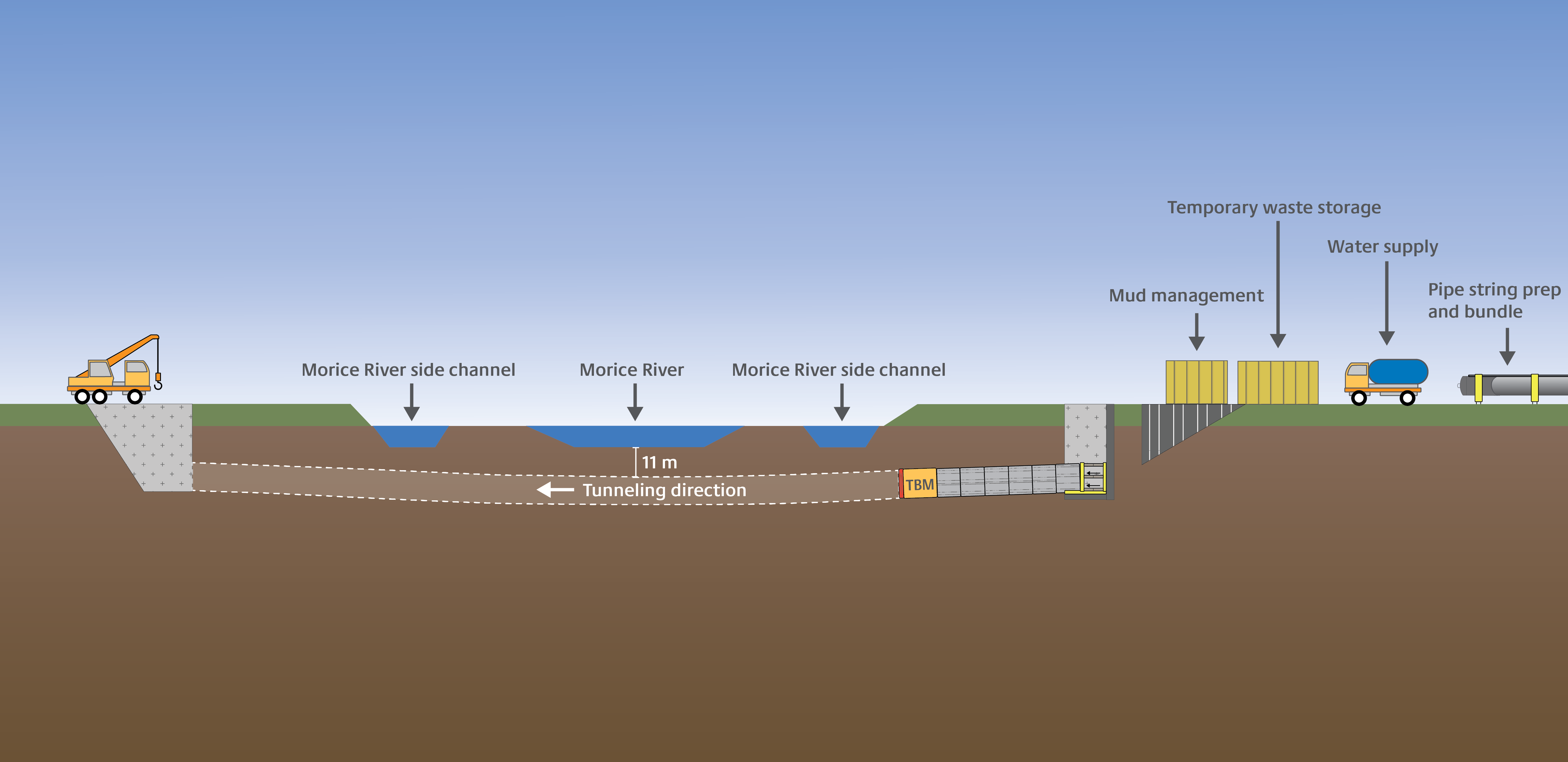
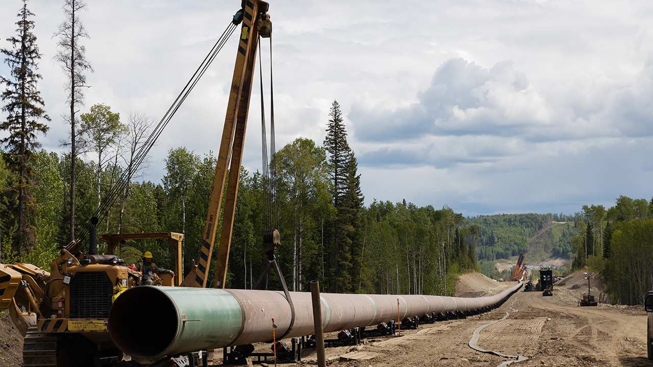
Trenchless crossings, like micro-tunnelling shown above, allow the pipe to be installed under the water body.

CGL-Microtunneling-Water-Crossing-illustration-v03-20211006_3.2.png

cgl murray HDD 1280x720.jpg

Creating a safe crossing: Murray River Trenchless Crossing

Installing a pipeline under the Murray River was no small feat, but it was one we spent many years planning and preparing for.

In July 2021, we completed the largest trenchless water crossing on the Coastal GasLink project, installing 1.3km and 1.2 million pounds of pipe under the Murray River using a 48-inch Horizontal Directional Drill (HDD). Most importantly, the installation was completed with zero safety incidents.

This major milestone was made possible through years of preparation and the expertise of many, including engineers, crossing companies, environmental specialists and surveyors, who together ensured the crossing was completed with no impact to the river.

Find out more about how we completed the Murray River HDD by watching this video.

The Canadian Navigable Waters Act

Coastal GasLink is committed to building and operating our natural gas pipeline project in accordance with regulatory requirements, including the Canadian Navigable Waters Act (CNWA).

Under the CNWA, owners of works (such as bridges and pipelines) who propose to construct, place, alter, rebuild, remove or decommission works that are in, on, over, under, through or across any navigable water may be required to apply for an approval to Transport Canada, or seek authorization through the public resolution process. The Navigation Protection Program (NPP) is responsible for administering and processing applications for approval and notifications for these works, and the Minister of Transport has the authority to issue terms and conditions with an approval.

Where it has been identified that works associated with construction of the Coastal GasLink pipeline will cross or potentially impact navigable waters, applications or notifications will be prepared and submitted through the NPP.

The creation of applications or notifications will automatically publish information of the work into the Government of Canada Common Project Search (CPS) website. In addition to the CPS, Coastal Gaslink is also responsible to publish a notice of the proposed work using the same official language used in the CPS.

Information for all CNWA notifications or applications submitted for Coastal Gaslink can be found on our Construction notifications page.

Coastal GasLink welcomes all input regarding CNWA Applications and Notifications. Have questions or concerns you want to share with us? You can provide feedback through the CPS.

Questions and answers


Who studies the rivers and streams? What are they looking for?

Since 2012, we’ve conducted environmental field programs that have been made of up of 72 fisheries and aquatics crews, who spent over 43,500 hours in the field. Crews included fisheries biologists, as well as First Nations participants, who gathered site-specific information on fish and fish habitat. This information helped us determine crossing methods, construction timing, and the best measures to reduce potential impacts.

Engineering field crews have spent over 16,500 hours in the field since the project began in 2012. They focus on surveying and investigating to help us refine the construction footprint and provide input into the engineering design. Assessments at water crossings are completed to ensure the appropriate crossing method is selected for each crossing. Their studies included geotechnical investigation on potential trenchless crossings, geophysical surveys, flow measurements, and assessments on water crossings.

How do you determine which water crossing approach to use?

Our project’s 670-kilometre right-of-way crosses many bodies of water and we approach each one with the utmost care to prevent adverse impacts on the environment. Prior to construction, information is collected about water bodies along the route, including environmental and technical assessments. Environmental assessments included studies of the aquatic environment – such as water flow, bank stability, the quantity and quality of fish habitat, wildlife and vegetation.

The technical feasibility of potential crossing methods is then determined based on site conditions, available workspace considerations, and environmental, geotechnical and geophysical data, input from Indigenous and local communities, and regulatory requirements.

What happens to the rivers and streams during construction?

During construction, we monitor rivers and streams to make sure our plans are effective. This means monitoring both the stream and the surrounding riverbanks to understand if the measures we’ve put in place to reduce impacts are working as we expected, and to determine if changes are needed. We compare downstream measurements to upstream measurements to monitor the quality of the water, and to make adjustments when needed.

When measuring the water quality, we look at the amount of oxygen in the water, acidity, small particles and different ions that show up in the water, and the water temperature. These measurements help ensure watercourses retain the qualities needed to support fish following construction. These activities will happen throughout the installation of the pipeline on the site, multiple times per day. If the monitoring shows any unusual results, we’ll address it immediately. This could mean installing erosion/sediment control barriers; temporarily stopping work until the water quality returns to acceptable levels; or rescheduling work until conditions are more favourable (such as avoiding working during heavy rainfall, or working in the morning during freeze/thaw cycles when the ground is still frozen).

How do you protect the fish and fish habitat during construction?

Fish matter to us. We’ve developed an Environmental Management Plan, which includes stringent measures to protect fish and fish habitat during construction. This includes measures such as:

    • Avoiding disturbance of or blocking access to important habitats during key times, such as spawning areas, migration routes and rearing areas.
    • Constructing when watercourses are dry or frozen as much as we can.
      Isolating stream flows so work can occur during periods of reduced flow or in areas isolated from the flow.
    • Relocating fish downstream from the work site during construction by a qualified professional.
    • Replacing appropriate material to the streambed such as clean gravel as part of restoration.
    • Re-grading, stabilizing, and seeding or planting approach slopes to grow vegetation to restore habitat along the riverbank and minimize potential for erosion.

There are claims being made that Lamprey Creek is "gone". Is this true? 

Lamprey Creek continues to flow. Controlled blasting activities by Lamprey Creek are part of ongoing clearing and grading activities around the creek. Mitigation measures are in place to protect the creek during construction and in accordance with regulatory requirements.

What happens after construction? Are the rivers and streams still safe?

Just because construction is done, doesn’t mean we disappear! We monitor the construction footprint to see how the water and surrounding vegetation return as part of our 5-year post-construction monitoring. We look at the effectiveness of measures we put in place to reduce impacts. During the operations phase of the project, surveillance activities such as fly overs will be used to monitor the right-of-way on a regular basis. In addition, our people on-the-ground may do site visits to follow-up on any noted change along the right-of-way.

By monitoring the rivers and streams after construction, we can ensure safe and reliable operations and measure how effective our mitigation and reclamation techniques were and determine if any further work may be needed.

Have more environmental questions? View our FAQs